|

Business Member
Home
E-Mail
|
Historical
Cooper
River
The
Cooper River,
a relatively short river system contained entirely within the lower
portion of the South Carolina
coastal plain and principally within
Berkeley County, stretches north along the east side of the Charleston peninsula.
Significant in the state’s history for more than three hundred
years, it is the primary watershed for an area characterized by a
complex network of tributaries, creeks, tidal marsh, and freshwater
wetlands. The confluence of the river’s East and West branches, at a
point historically known as the Tee, is approximately twenty miles
north of where it empties into Charleston Harbor.
The headwaters of the East Branch are formed by Quinby and Huger
Creeks in the Huger vicinity, while the West Branch begins some
seventeen miles north of the Tee near Moncks Corner. These two
branches, along with other tributaries and creeks, form the nucleus
of an extremely fertile region consisting of tidal marshes, former
tidal ricefields, inland ricefields and reserves, as well as upland
agricultural fields and timbered and reforested woodlands.
By the mid-eighteenth century, the
Cooper
River served not only as a
principal transportation route for plantation goods,
services, and people but also played a vital role in the
successful production of rice. The earliest rice cultivation
was on inland fields created from swamps and along creeks
and branches at some distance from the river, in some cases
more than a mile, and removed from tidal influence. During
the mid-eighteenth century the technology to control tidal
flooding of the fields was introduced to the Cooper River,
and the tidal marshes became the focus of rice cultivation.
In many cases the old inland fields were abandoned and
appear as “Old Fields” or “Old Rice Fields” on eighteenth
and nineteenth century maps and plats.
Today’s landscape features many fertile underwater fields along the
river’s edge and inland freshwater swamps where rice once
flourished. A complex system of dikes, dams, canals,
and trunks, much of which is either still visible or nearly intact
throughout the district, made rice production both possible and
profitable. These landscape features are tangible evidence of the
work of thousands of slaves who provided the labor force for the
plantations.
By the mid-eighteenth century, the
Cooper
River served not only as a
principal transportation route for plantation goods, services, and
people but also played a vital role in the successful production of
rice. The earliest rice cultivation was on inland fields created
from swamps and along creeks and branches at some distance from the
river, in some cases more than a mile, and removed from tidal
influence.
During the mid-eighteenth century the technology to control
tidal flooding of the fields was introduced to the
Cooper
River, and the tidal
marshes became the focus of rice cultivation. In many cases the old
inland fields were abandoned and appear as “Old Fields” or “Old Rice
Fields” on eighteenth and nineteenth century maps and plats. Some
inland fields, however, continued to be used with reservoirs, often
called reserves, used for flooding the fields.
Today’s landscape features many fertile underwater fields
along the river’s edge and inland freshwater swamps where rice once
flourished. A complex system of dikes, dams, canals, and trunks,
much of which is either still visible or nearly intact throughout
the district, made rice production both possible and profitable.
These landscape features are tangible evidence of the work of
thousands of slaves who provided the labor force for the
plantations.
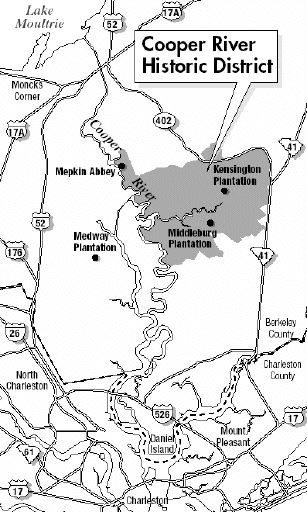
The
Cooper River Historic District
contains an approximate
twenty-five mile segment of the Cooper
River
system in Berkeley
County. This includes the
entire East Branch, a portion of the West Branch, and an area of the
river below their confluence at the Tee. The river has a fairly deep
channel (from twenty feet at the Tee to eight feet at the mouth of
Quinby Creek) and was navigable by sloops and schooners along the
section within the historic district.
The inclusion of the
Cooper
River as a contributing
property in the district attests to its importance in
transportation, industry and agriculture. Indeed, the river is the
very heart of this district, an artery by which plantation goods
were transported to and from markets in Charleston and elsewhere.
\
Historic Resources of the Cooper River, ca.
1670-ca. 1950
Name of Multiple Property Listing Berkeley County, South Carolina
United States Department of the Interior
National Park
Service
National Register of Historic Places
|


![]() Simply the Best In Blackwater Diving
Simply the Best In Blackwater Diving
![]()
