Simply the Best In Blackwater Diving
COOPER RIVER DIVE CHARTERS
Simply the Best In Blackwater Diving
Copyright 2020
Cooper River Dive Charters
260 Amy Drive
Goose Creek, SC 29445
Dive Sites
Little Pine Island
"The Camp Ground"
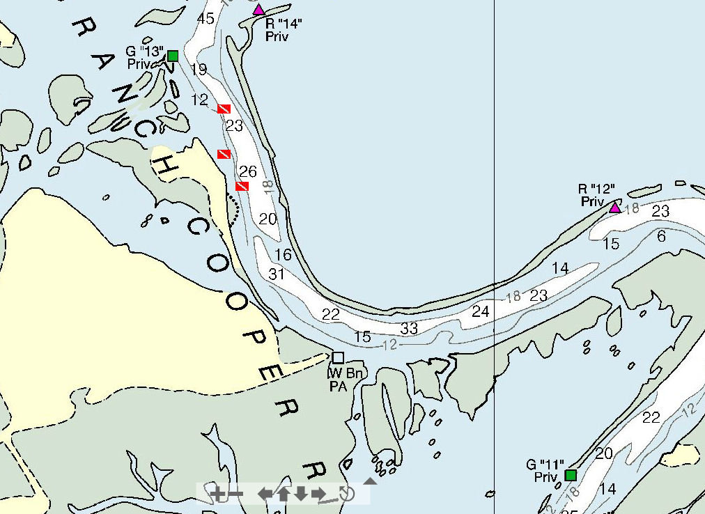
Cooper River West Branch
Site: Name: Little Pine Island, aka "The Camp Ground"
River: Cooper River
Coordinates: GPS Coordinates N33 05.043 W79 56.562
NOAA Tidal Station: Download Tidal Chart Old Rice Mill
Best Dive: The channel of the West Branch of the Cooper River narrows in this area the ebb and flow tidal flow can also increase significantly with current reaching 3 knots at times. The best time to dive is during the slowing of the predicated tidal flow using the tidale predictions at the Old Rice Mill prediction or the Pimlico Tidal Monitoring Station. Diving 30 minutes before the ebb tide. Divers will have a stiff but manageable current that, will be decreasing during dives. This may give you a 30 to 40-minute surface interval during slack tide, when visible reaches near zero from the sediments/silt settling along the river bottom. The incoming tidal flow will begin offering divers an hour to an hour and a half of manageable current flow, before becoming strong.
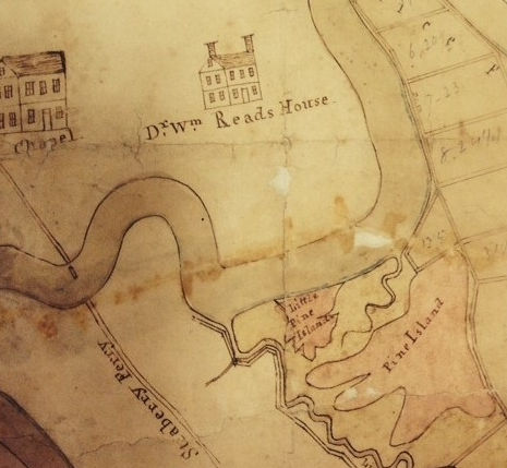
Description: Pine Island also locally known as "The Camp Ground." See 1700's map drawing of Childsbury showing the location of Pine Island and Little Pine Island along the West Branch of the Cooper.
Dive Briefing: Divers should be made aware of the boat traffic and tidal conditions as mentioned above in Best Dive. The area along the island is shallow depths range from 5 to 10 feet along the shore and marsh. Depths increase to about 16 to 18 feet about a hundred feet from the bank the drops to approximately 30 to 34 depending on tidal conditions. The transition from the shallow bank to the mid-channel area offers divers a 10 to 12-foot drop. While in the shallow area a diver looking down into the channel, will see what appears like a deep dark hole. Sliding down into this hole divers will enter a fossil bed with thick heavy gravel. This area is known for the occasional large megalodon tooth and a variety of other fossils including some nice C. Angustidens, C. Auriculatus., Extinct Great White, Mako.
The Little Pine Island and Pine Island are well known for projectile points and each year several "points" have been recovered from the area in front of high bank area and the entrance to Durham Creek. The shallow is described above also has fossils even as close to the bank (insert alligator warning here) near the soft clay are on the marsh.
Hazards: Boat Traffic - Possible Heavy Recreational Boat Traffic, Little Pine Island is very near Durham Creek enters the West Branch of the Cooper River and boats leaving Cypress Gardens Landing exit the creek here.. B.A.S.S. Fishermen fishing tournaments and recreational boaters will be entering and leaving Durham Creek, generally there are NO large tugs, barges or vessels in this area of the Cooper River, but they may travel through this area into lake Moultrie above the town of Moncks Corner, SC to the Santee Cooper Lakes.
Point if interest: Numerous bottle tops and bottoms have been found in the area just South East of Little Pine Island along the bank of Pine Island. (GPS N33 04.847 W79 56.470) Several whole wine and Mallet type bottles have been recovered off pine Island near the bank in this sand area. When diving this area divers will find bottoms and tops/lips to these old bottles.


Below: Excerpt from an 1700's??? hand drawn map of the Cooper River showing Strawberry Ferry, Pice Hope Plantation. The area locally known and commonly called "The Camp Ground" was known as Little Pine Island. Notice how the small creek that was replaced when durham Creek was dug out in the 1940 New Deal-era known as Santee Cooper Power and Navigation Project. Thsi creek now provides the intake of fresh water to the SCE&G (South Carolina Generating Company) Williams Station a 633 megawatt (MW) coal-fired power station near Goose Creek, South Carolina owned and operated by SCANA energy affiliate.
Dr. Read's House on the map detail today is known as Rice Hope Plantation. It was orginally built in 1691 by Daniel Huger on 690 acres of land. See Rice Hope Plantation


